Krutoi Bereg
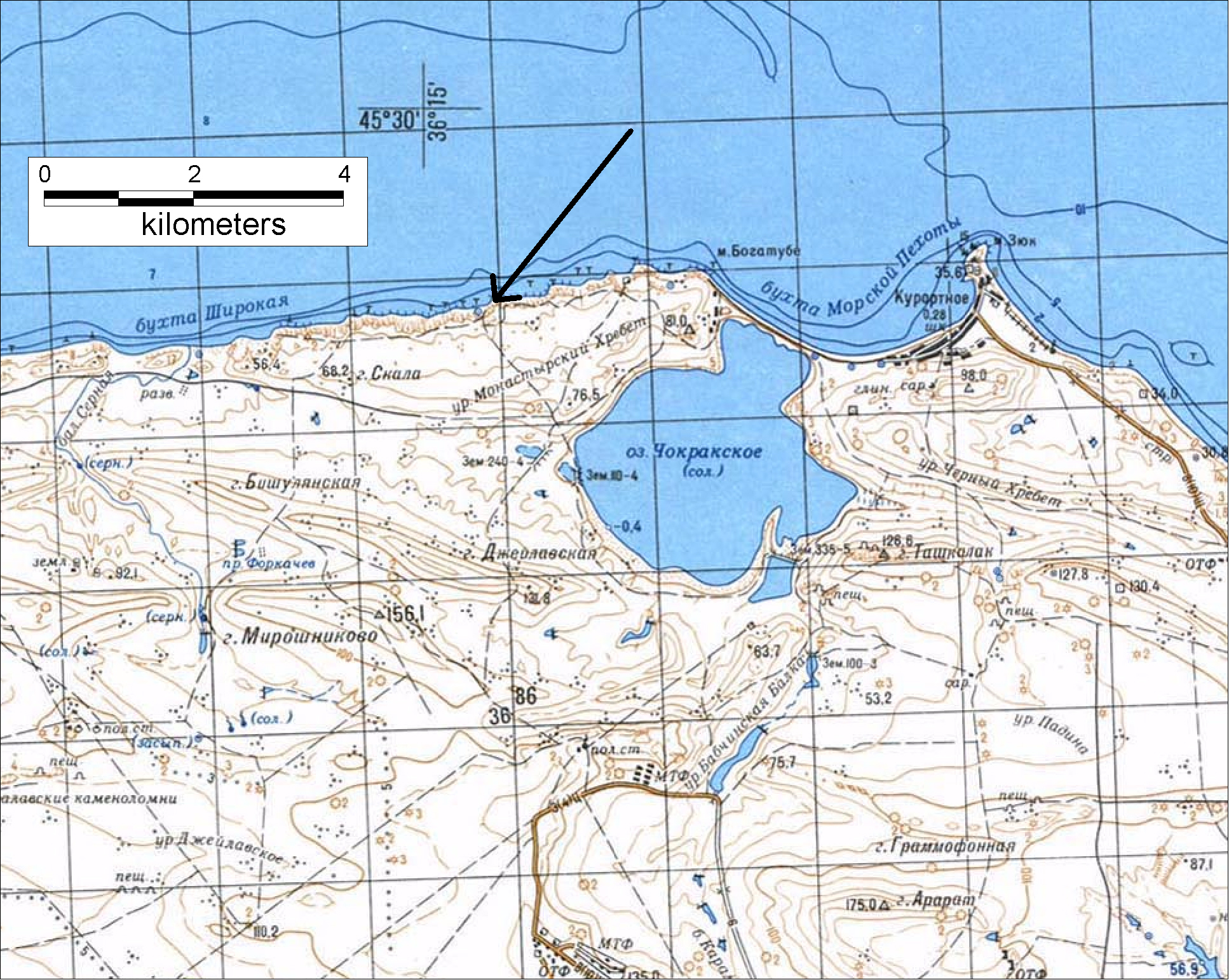
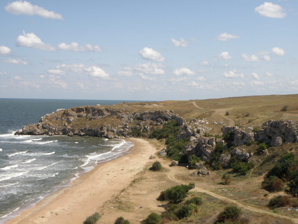
The “Krutoi Bereg” (Steep Shore) settlement is situated in the Leninskii District of the Republic of Crimea, 8.5 kilometres west of Zyuk Cape and east of so-called “Korovya bukhta” (Cow Bay) on the relatively even ground of a small cape with an area of approximately 50,000 square metres. It is bordered to the North, East and West by the Sea of Azov. On its western and eastern edge the rocky coast-line is high and steep and in the North there is a sheer drop into a small bay (Map, Topography, Orthophoto).
The site was discovered at the beginning of the 1980s and excavation work began there in 1985 and continued without interruption until 1988, led by I.M.Bezruchenko [Bezruchenko 1985, 1986, 1987, 1988]. Two trenches were sunk: one in the western part of the cape very close to the steep cliffs over a total area of 150 m², which was investigated in 1985 (the “Western Trench”), while the second, in the north-eastern part of the cape and covering a total area of approximately 1,225 m² – the “Eastern Trench” – was excavated from 1985 to 1988. In 2009-2015 archaeological investigations were carried out in the central part of the fortified settlement (the “Central Trench”) led by A.V.Kovalchuk, in the course of which an area of approximately 650 m² was excavated [Kovalchuk, 2015, pp. 779-781].
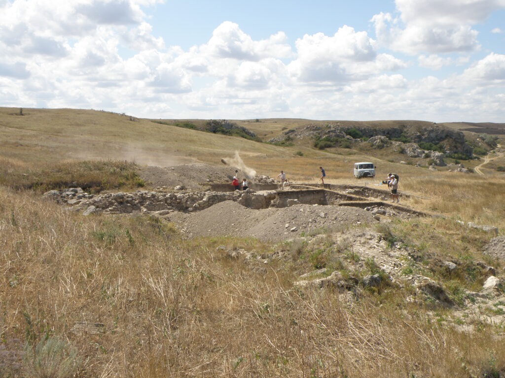
The site’s state of preservation was satisfactory. The ancient ground surface in its central part had not really been disturbed at all – only in the area, where it joined the Eastern Trench and where two looters’ pits were identified. A significant part of the site had collapsed into the sea in the East and North-East and, as a result of soil erosion, this process still continues today. The eastern part of the site has been seriously damaged (in the southern part of its northern section) by two trenches dating from the Classical era and also by pits, dug-outs, small trenches and also two large ones dating from the time of the Great Patriotic War (1941-1945).
While the archaeological excavations were being carried out in the southern part of the cape, a large defensive wall was discovered (Walls № 1, 1a, 1b) marking off the settlement, from the western edge of the cape across to the eastern one on the steppe side, and also dwellings and outhouses to the North of it. The time during which the site existed was also established: a period of between 150 and 180 years – from the end of the 4th century BC to the middle of the 2nd century BC. Numerous and diverse buildings were excavated in the settlement: dwellings, work premises, streets), which had been re-built and re-arranged several times. Today it is possible to distinguish fairly confidently at least four building periods. We would define as such those periods when fundamental re-building was carried out within the fortified settlement. Such periods would be reflected in major changes to the general arrangement of buildings within the site (when their location and orientation were altered). These large-scale changes were usually connected with events of a catastrophic nature in the region (of a natural or anthropogenic character): they would manifest themselves in the stratigraphy by layers resulting from fire and/or destruction. Within such building periods it was also possible to single out certain phases reflected in smaller-scale re-building of various premises (blocking up of doors and windows, extensions, changes to lay-out within particular buildings and so on).
Some questions remain unanswered to this day – first and foremost those connected with the defences for the fortified settlement: had there been bastions along the defensive wall to the West and East and where the central gate leading into the settlement had stood. It has not yet proved possible to establish whether there had been a rampart and moat south of Wall № 1. Nor is the nature of the lay-out in the north-eastern parts of the settlement clear.
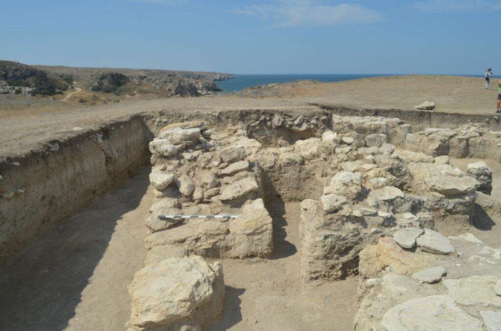
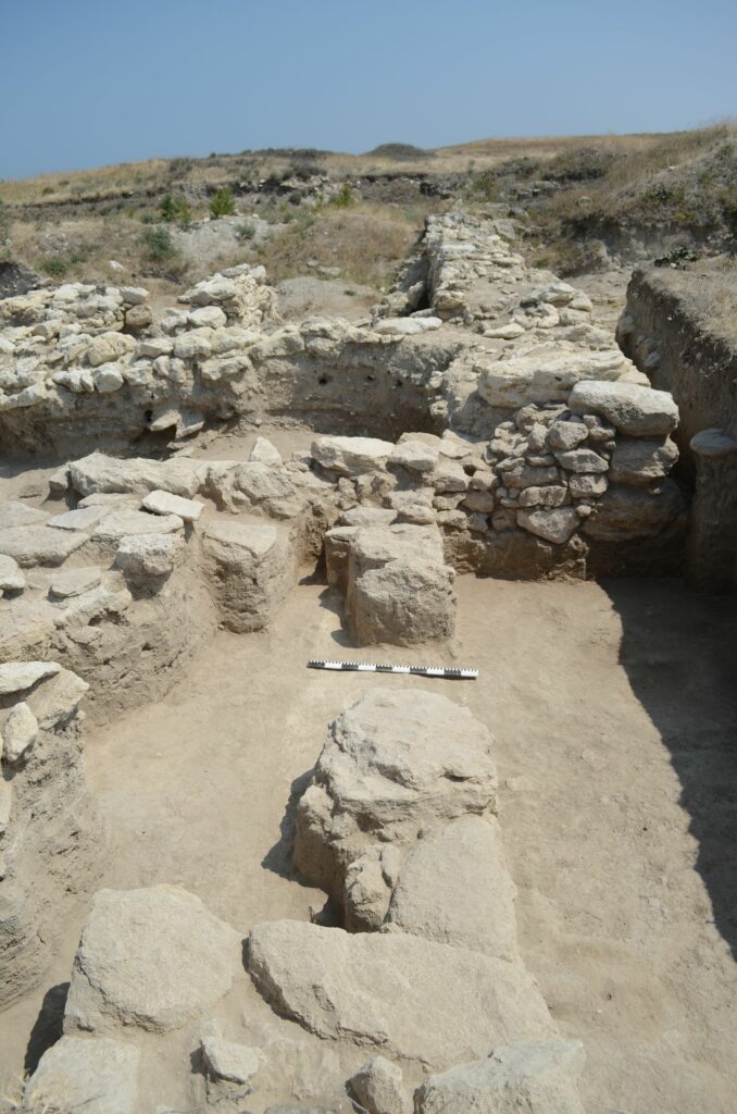
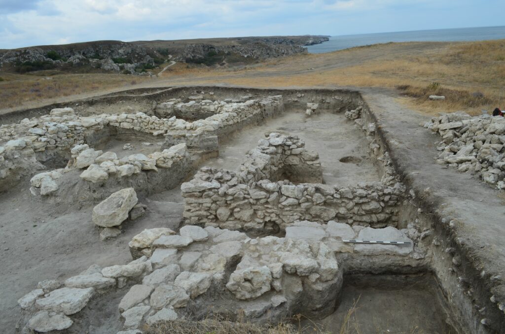
The lay-out of the settlement is different in the various parts of the site: this is the result, first and foremost, of two factors – the original relief of the ancient ground surface and the proximity of outcrops of the natural rock. In the western and central parts of the settlement the ancient ground surface is relatively flat and sloping only gently down towards the North and West. It is only in the eastern part of the settlement that there is any significant drop [Maslennikov, 1998, 98, Fig. 63, Fig. 1]. In the northern and north-eastern parts of the settlement the natural rock is quite near the surface and in places even protrudes above it. In view of these features of the terrain, the Rooms in the Eastern Trench have been arranged across a number of terraces (Fig. 1, 3). Walls № 15 and № 16 are retaining walls for Room 4 , while Wall № 7 is a retaining wall for Room 2 [Bezruchenko, 1985, p. 50, 57]. In section КЛ8-9, despite the poor state of preservation of the remains of buildings, it was possible to establish that all the walls discovered along the cliff to the far East of the site were retaining walls and designed to support the next terrace. To the South of this section, Walls № 29 and № 32 are the retaining ones for the large open courtyard located in the north-western part of the Eastern Trench [Bezruchenko, 1987, p. 55]. As for the features of this structure, all sections of stone fabric are similar to each other. They are all single-faced, single-layer (apart from Wall № 29, which is double-layer) and irregular, consisting of medium-sized and small un-worked pieces of limestone.
This means that in the Eastern Trench it is possible to distinguish at least five terraces. Room 17 is located on Terrace 1. Here on the edge of the cliff and because of the outcrops of the natural rock, the walls have been built straight on to the hewn rock surface which also serves as the Room’s floor. The next terrace lies to the West and extends until it reaches Wall 29. Built on the latter is Room 9 and Paved Walkway 5. In the northern part of the retaining wall of that terrace is Wall № 7, east of which the building remains have collapsed to a large extent. Room 1 had also been erected on that terrace. Wall № 15 is the retaining wall for the next, third terrace, on which Room 2 is located. Wall № 16 forms the end of another terrace to the South of it with the remains of an open courtyard and Room 3. Finally, the fifth terrace is located in the north-western part of the settlement, north of retaining wall № 32. This part of the site has so far not been investigated.
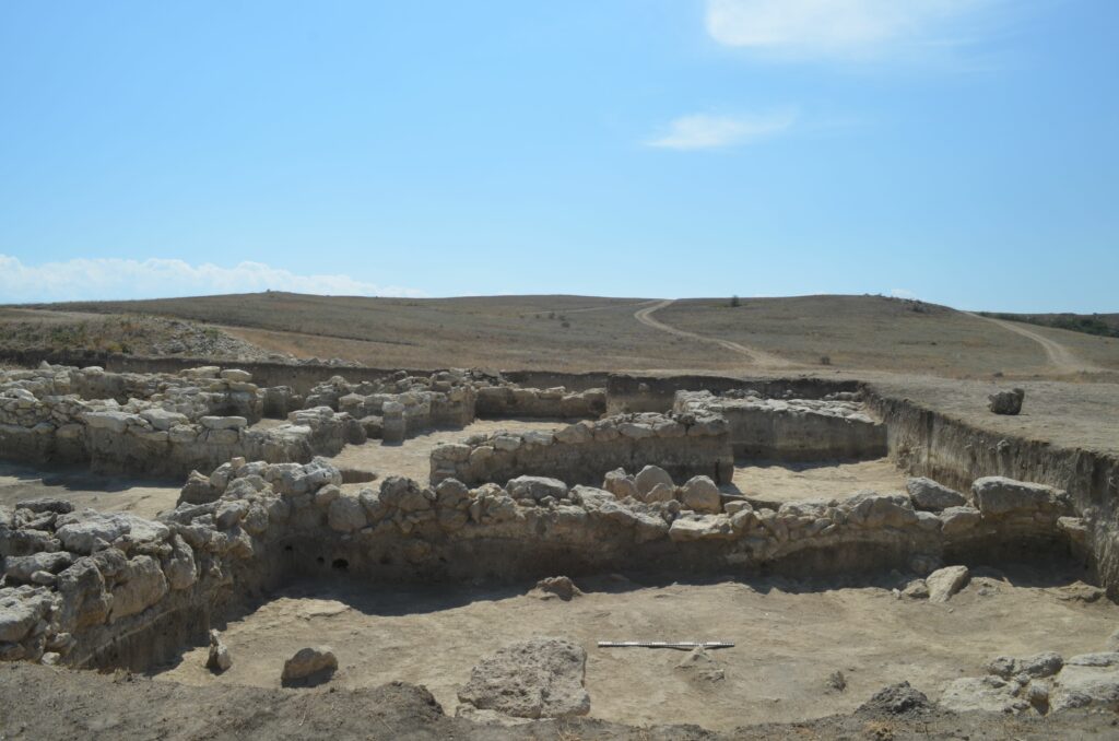
In the central and western part of the settlement the ancient ground surface is a relatively even plateau, without any significant changes in level and the Rooms discovered here are arranged on one and the same level.
In the South of the settlement the terrain rises slightly, like a rampart extending West-East, separating the cape from the steppe. This bank is clearly visible both in the aerial photographs [Maslennikov, 1998, p. 99, Fig. 64, Fig.1] and also with the naked eye in the local landscape. It was already clear at the time, when the first archaeological investigations were being carried out, that this rise in the terrain was where a defensive wall had been (Wall № 1).
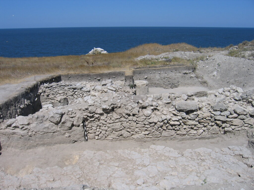
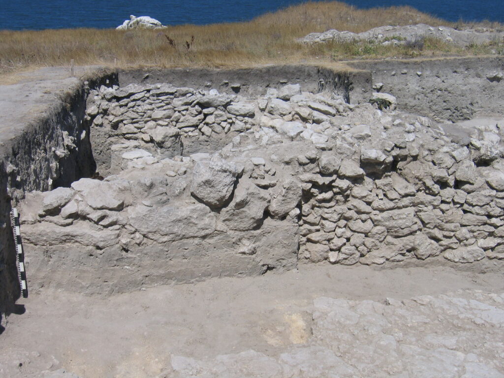
Wall No. 1 marks the extent of the whole settlement on the south side, along a line running West-East. The part of it already cleared extends for about 69 metres (9.5 metres in the western section, 30 metres in the eastern section and 25 metres in the central one) and its width is 1.2 -1.5 metres. In places, as many as ten rows of stones have survived (to a height of between 1.22 and 1.7 metres) but, in certain parts, the wall has been seriously damaged (reduced to a height measuring as little as 42cms). The stonework consists mainly of large and rough pieces of limestone (measuring, for example, 58 x 35 x 15cms; 49 x 50 x 16cms and 68 x 24 x 12cms) and the spaces between them are filled with medium-sized or small stones (measuring 13 x 14 x 5cms; 21 x 8 x 9cms). The stonework consists of three layers and is double-faced and irregular: in places it was bedded and neat. Small slits in it (2-4mms) have been filled in with clay. The outer surfaces of the walls are even and vertical. The top stones of the walls often protrude above the ancient ground surface, while the bases of the walls lie on a layer of dark-brown loam (buried soil) at a depth of 1.1-1.2 metres from the ground surface.
In its southern section, the course of the defensive wall forms a broken line, with parts of it pointing in different directions. This would evidently appear to be because of features of the terrain’s relief or various stages in the re-building of the structure. In the section of the site already excavated, three parts of the wall orientated in different directions can be noted and three places where the wall has been shifted towards the North. For example, the extreme eastern section of the wall (Wall № 1a) follows a NW-SE line and then, near the blocked small gate, the wall shifts northwards and the stonework after that is clearly in line with the points of the compass. Thirty metres further on, near a place where re-building has occurred and the wall has been badly damaged, it shifts northwards again over 1.6 metres, while the wall as a whole (Wall № 1б) keeps to its former orientation. In the Western Trench, the section of Wall № 1 which has been cleared, had an orientation virtually identical to that of the far eastern section – namely NW-SE – and it lies to the North of the central section, which testifies to another shift of the wall’s course northwards within a section not yet excavated.

Another question still to be resolved is that concerning the central gate of the fortified settlement. It would seem that the search for it needs to be concentrated in the section of the site between the Central and the Western Trench, which has not yet been excavated. A.A.Maslennikov is of the opinion that the wall was originally built in three independent parts: two at the sides and the central part shifted further north. In his view, they were not linked together and “the intervals between them served as passages leading into the settlement” [Maslennikov, 1998, p. 209]. This suggestion appears plausible but it should be noted that the central part of the gate is not of the same type as the side parts. Nor is it possible to rule out the probability that the gate is actually located in the north-eastern part of the site. It is also possible that there had at one time been a second passage within the central part of the gate, at the place where there had been major collapse and then re-building of Wall № 1 (Quadrant H2).
In 2009 a small rise (approx. 50cms) in the relief of the site south of the defensive wall was noted, which had been formed by the remains of the badly eroded rampart. The presence of something in the way of a rampart was also indicated by the old geophysical data obtained earlier [Maslennikov, 1999, p. 209].
In 2009 and 2011 trenches were dug along the outer surfaces of Wall No. 1 and these revealed that, when the defensive wall had been built, first of all a ditch approximately 2.5 metres wide had been cut out in the natural rock and then filled with earth (dark-brown loam with small inclusions of white natural clay) and immediately above that the stonework had been erected. The material from the trench consisted of fragments of amphorae from Heraklea, Sinope, Knidos and Colchis. In addition the handle of an amphora from Sinope was found bearing a stamp of astynomos Epielpes (2009, Inventory No. 72). This means that the finds made it possible to determine the time when the wall had been erected as the first quarter of the 3rd century BC.
The reinforcement of the defensive wall on the outside (from the South) with two rows of large dressed stones (measuring 45 x 69 x 20cms; 1 metre x 60cms x 60cms) took place at a somewhat later date. The level of the bases of the stones was 50cms from the level of the ancient ground surface. This additional ‘armour’ approximately 50cms wide survived in certain sections of the wall (Quadrants Б2, В2, Г2, Д2).
The reinforcement of the wall can probably be explained with reference to the increased military threat from the steppes. This was borne out by the discovery – south of the wall and outside the boundary of the settlement in quadrants Б1 and В1 – of a burnt layer of material approximately 20cms thick. It stretched in a narrow strip (2.2 metres wide in its western part and 50cms wide in its eastern part) along the wall W-E over a distance of 4.10 metres. The finds from the layer of yellow loam immediately underneath the burnt layer included fragments of amphorae from Sinope and Heraklea and also tableware fragments of Bosporan manufacture. Attention should be drawn in particular to stamps on amphora handles from Sinope: stamps of two manufacturers, Ariston and Kraton 250 BC (2009, Inventory Nos. 91-92) and an imprint of magistrate Eucharistos, son of Demetrios, who held office in 260-250 BC (2009, Inventory № 93). The finds taken together make it possible to date the formation of the burnt level and the reinforcement of Wall № 1 in the South to approximately the middle of the 3rd century BC. Attention should also be drawn to finds of projectiles for catapults, arrows of a Scythian type and sling stones. Evidently this part of a rural area had been effected by military-cum-political events connected with the Sarmatian conquest of Greater Scythia.
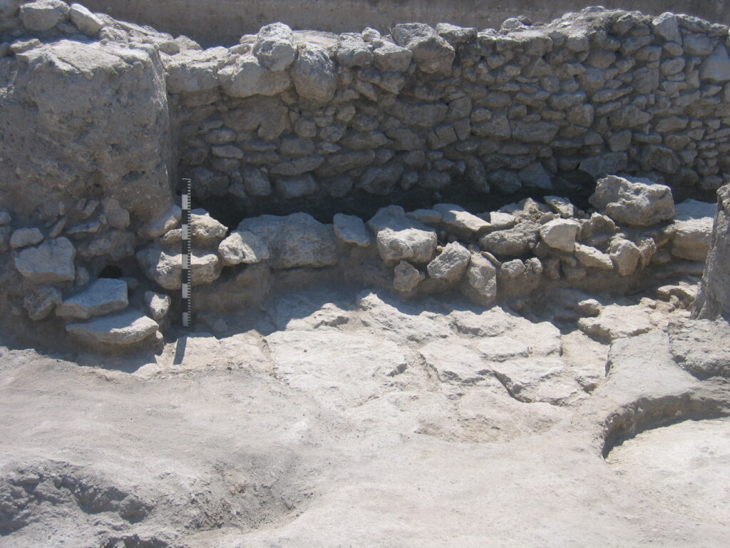
Wall No. 1 underwent several phases of re-building during the period of the settlement’s existence. Traces of them have survived in the central part of the site (Quadrant A2, H2). In that section of the site the course of Wall № 1 was shifted 1.6 metres further north in relation to the main line of the wall in the east quadrants. At that point the wall made a small turn northwards and then westwards before subsequently resuming its former direction. It is interesting to note that the wall – up until the turn northwards – retained its three-layered structure, namely two rows of stones and a rubble core. This is a slightly unusual procedure if we consider the west surface of Wall № 1 in Quadrant A2 as the front surface. To all appearances, initially Wall № 1 was straight in that section, without a bend in it. After its collapse the wall was restored – not in its former position though, but slightly further north, retaining its old direction in the form of an extension built up against it from the North (Wall № 1б). The reasons for this re-building are not clear: all that seems worth noting is a layer of ash west of the place where it collapsed. To judge from the level of the bases of Walls № 1 and № 1b, the destruction of the first wall and the appearance (restoration) of the second took place in fairly rapid succession. In the adjacent quadrant, Wall № 1б had suffered major damage: all that survived were traces of its dismantling, in the form of small limestone inclusions in the brown loam.
The continuation of Wall № 1 is Wall № 1a, which protects the settlement in the South-East and extends SW-NE. It is similar in character to Wall № 1: its stonework consists of three layers and it is double-faced, irregular and bedded in places. The largest stones in it have been laid out in a neat chessboard pattern. The length of wall already excavated totals 11 metres: its width is 1.4 metres, it has survived to a height of 1.6 metres in the eastern part and one of 1.2 metres in the western part [Bezruchenko, 1988, p.85]. At one time there had been a small gated passage between Wall № 1 and Wall № 1a leading into the settlement, formed when Wall № 1 had overlapped Wall № 1a. Later, the passage had been blocked out, forming a small ridge like a redant – an open field fortification [Maslennikov, 1998, p. 210, Figs. 143-144]. On the inside of the wall – the settlement side – there had been a flight of steps leading up onto that ridge, of which three steps had survived. To judge from the level where its bottom stones had been laid out, the flight of steps had been built at the same time as the blocked passage [Bezruchenko, 1988, p.85]. A.A.Maslennikov points out that the ridge, which had emerged, served as a kind of unusual fortification for the central entrance into the fortified settlement and had supplied the “need for the flank defence of the assumed gate” [Maslennikov, 1998, p. 209]. This assumption has so far not been confirmed because no passage has been found in the immediate vicinity of the structure.
Wall № 1a was evidently erected at the same time as Wall № 1 – no later than the first third of the 3rd century BC. This is borne out by the finds discovered at the base of the stonework.
To the North of the defensive wall and parallel to it – at a distance of 20-50 cms – the remains of Wall № 69 were located. The wall was accurately orientated along an E-W line and its stonework consisted of two layers, which were double-faced and irregular and consisted mainly of large stones. To judge from the stratigraphy, the erection of this wall would have preceded the building of Wall № 1. The function of this wall is not clear: no other structures immediately adjacent to it have been identified. It is possible that Wall № 69 constitutes the remains of a former dwelling, which existed before defensive Wall № 1 was built or another wall, which had been enclosing the settlement in the South before Wall № 1 had been built.
The walls of Rooms 12-13 used as dwellings (№ 50, № 51 and № 52) in the Eastern Trench, were built right up against Wall № 1: also Wall № 71a belonging to Room 3 and Wall № 94 belonging to Room 2 in the Central Trench and Walls № 3 and №4 belonging to Room 2 in the Western Trench.
The earliest buildings in the settlement are three dug-outs discovered in the south-eastern part of the fortified settlement in 1988 [Bezruchenko, 1988, pp. 72-74]. Also erected in the settlement’s first building period was Wall № 69 described above and also a large proportion of the rubbish pits dug in the layer of yellow natural clay or cut out of the natural rock.
Dug-out № 2 with an area of 1.6 x 1.7 metres was discovered under the second level of the floor in Room 11 in Eastern Trench I, in its north-eastern section, built up against an outcrop of the natural rock [Bezruchenko, 1988, p.73]. In the north-eastern corner a stove with a clay base was found, which was enclosed on all sides by vertically arranged slabs. In its in-fill, part of a human mandible was found and fragments of amphorae from Sinope, Colchis, Rhodos, Heraklea, Chios, Knidos, Chersonesos and Sinopean stamps of the astonymoi Hekataios (1988, Inventory No. 387), Aischines (1988, Inventory № 393) dating from 280-270 BC.
Dug-out № 3 was discovered north of Room № 12 in the Eastern Trench and is a pit of irregular shape measuring 3.4 x 2.8 metres with vertical walls. To the North and East of the dug-out there are two pits (№ 25 and № 27) separated from the dug-out by two metres of stonework [Bezruchenko, 1988, pp. 74-75]. The floor is provided by the natural rock. In the in-fill of the dug-out, fragments of amphorae from Sinope, Rhodos, Heraklea and Colchis were found and there was a stamp on a Sinopean handle of the magistrate Dionysios, son of Apemantos, who held his post between 240 and 230 BC (1988, Inventory № 391). A trench dating from the Classical period runs through part of Dug-out №3, which explains how some late material found its way into the in-fill.
All the dug-outs were evidently destroyed in a powerful fire. In the Eastern Trench, the structures dating from the first building period were covered over with a burnt layer [Bezruchenko, 1988, pp. 81-82], which was not recorded in the central part.
Above the burnt layer and over the whole of the settlement there was a layer of white limestone chips, which served as a levelling layer. Structures of the second building period had been erected on it – Defensive Wall № 1, outbuildings and also rooms used as dwellings, most of which were discovered in a seriously damaged state. In particular, Room 14a in the Eastern Trench dates from that period. A large part of it had later been covered over by Room 14. All that had survived of Room 14 was its south-western part (Wall № 48 and Wall № 47) concealed below a wall of Room 14 [Bezruchenko, 1987, p. 57, Fig. 2]. In the northern part of the settlement Rooms 3 and 4 date from the early period [Bezruchenko, 1985, p. 47].
In the Central Trench, two groups of Rooms can be singled out, which differ as regards their orientation. The orientation of one group deviates from the points of the compass by 15 degrees (Rooms 3, 4, 6, 10, 13, 14, 15), while the second is precisely aligned with the points of the compass (Rooms 1, 2, 5, 7, 8, 9, 12).
As a result of numerous instances of re-building and the poor state of the surviving stonework, it is not always possible to state with any confidence which of the structures belonged to the initial period in the existence of the site and which to a later one. The general impression, however, is that the structures with a deviation from the points of the compass in their orientation belong to the earlier period. The base of most of the stonework lies on the layer of buried soil, and the Rooms in the southern part of the settlement are not built up against the defensive wall but have been constructed at some distance from it. Rooms 4, 10, 13, 14 and 15 in the Central Trench can confidently be classified as belonging to that period and also certain fragmentary remains of structures, such as Wall № 105, for instance.
Somewhat later, during the third building period, districts appeared made up of single-chamber houses, orientated in accordance with the points of the compass and built in lines. Their measurements were as follows (in the Eastern Trench: Room 2 measured 3.68 x 1.52 x 4.10 x 4.5 metres; Room 3 measured 25 m²; Room 6 measured 6.5 m²; in the Central Trench: Room 6 measured 3.5 x 4.5 metres; Room 8 measured 8.27 x 5.4 metres; Room 12 measured 3.56 x 2.52 x 3.4 x 2.4 metres; Room 11 measured 5.06 x 3.26 x 4.74 x 3.52 metres). In the Eastern Trench Rooms 1, 5, 11, 12, 13, 14 relate to that building period. Rooms 12-13 were built up against Defensive Wall № 1. In the northern and eastern part of the trench the walls of the houses were positioned up against outcrops of the natural rock (Room 5). Many structures had shared walls. In the Central Trench, Rooms 1, 2, 3, 5, 7, 8, 9 and 12 date from that time. They were not, however, all built at the same time: Room 2 was constructed later than Rooms 1 and 3. In the course of that period some of the structures were partly re-built. At one point in time the original passage into Room 1 in the Central Trench was blocked off (Wall № 66). In addition, in Room 14 in the Eastern Trench another floor was discovered under the uppermost one and between the two there was a burnt interlayer.
A large proportion of the Rooms were rectangular in plan, but in some of them the walls meet at an obtuse angle, making the structures involved acquire a trapezoidal shape (Room 1 in the Eastern Trench, Room 4 in the Central Trench). Some houses had two storeys (a basement or a semi-basement by way of a lower storey) and in these were found staircases leading to an upper floor. In the corners of Rooms 7 and 11 small, shallow recesses were found in the corners (30-35 cms in diameter and 7-20 cms in depth), which would evidently have been recesses designed for the pillars supporting the roof of the upper storey. The floors in most of the structures were layers of compacted clay, which sometimes contained inclusions of limestone chips and charcoal. Some floors are encountered paved with small flat slabs of limestone. The passages leading into the Rooms are small – between 70 cms and 1 metre in width and made of large limestone blocks. Sometimes there were steps leading into the rooms (Room 1, for example). In most of the buildings there were small stone recesses in the corners, providing a semi-circular or rectangular storage space closed off by vertically arranged flat stones. In Rooms 1 and 4 in the Eastern Trench small semi-circular stoves were found. In Room 6 in the Central Trench there was a round hearth and next to it a range of vessels and terracottas, indicating that rituals of a domestic cult would have been celebrated there.
In the northern part of the settlement the buildings were quite close together and most of the streets were between 1.2 and 1.5 metres wide. They were often paved with rough slabs of limestone. Judging by the finds, the buildings of that period date from between the middle and the last quarter of the 3rd century BC.
The buildings of the latest period in the life of the settlement (fourth building period – first half of the 2nd century BC) were built up against defensive Wall № 1 on its north side. This group in the Central Trench included Room 7, a drain, the heaped remains from inside a stove, Wall № 98, Paved Walkways № 1 and № 9. They had been constructed after Wall № 1 had been destroyed.
Around the middle of the 2nd century BC the inhabitants abandoned the settlement. It began gradually to collapse and fall into decline. Subsequently there was no new chapter in its existence.
Let us now examine certain categories of the finds. Thirty-four coins were found in the settlement and a large proportion of these dated from the first half or middle of the 3rd century BC [Maslennikov, 2015, p. 139]. In the main these were coins of Panticapaeum of the XLI type – № 4 and № 5 (Zograf, 1951]. Earlier coins of the late-4th century and first half of the 3rd century BC were also found with counter-stamps in the form of an eight-pointed star or a quiver-case with a gorytos and a bow [Maslennikov, 2015, p. 145].
The collection of black-gloss vessels ranges in date from 325/300 to 150/125 BC [Maslennikov, 2016, p. 53, Plate 1]. Three vessels do not fall within this range: a lekythos fragment of earlier date – end of the 5th century BC [Ibid. p. 57] and two fragments of small bowls, which – on the basis of certain features of their glaze – were assumed to date from a period no earlier than the third quarter of the 2nd century BC [Ibid. p.54]. The spread of this ceramic material over time presents the following picture: a significant number of vessels was already to be found in the settlement in the first quarter of the 3rd century BC, peaking in the second quarter of that century, and then over the course of the 2nd century BC the number of black-gloss vessels slowly decreased [Ibid., p.53, Plate 1].
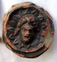
Pottery with decoration in relief is represented by a fairly large number of Megarian bowls (46 fragments) encountered mainly in the upper levels of the site. A fragment of a black-gloss cup bearing a medallion worked in relief was also found in the settlement: in the field of the cup the head of Helios? was depicted surrounded by leaves (2011, Inventory № 218). These so-called “Calenian” ware cups were encountered in Greece and Egypt but such finds were rare in the North Pontic region. A vessel of this kind found in Tiramba was recorded with a depiction of Isis and Serapis separated by a staff [Finogenova, 2010, pp. 368-369] and three fragments of such a vessel in Hermonassa – one with a medallion similar to that found in Tiramba and two others with busts of Pan holding a thyrsos and a bunch of grapes [Korovina, 2002, p. 114, p. XXII, Plate 19; Finogenova, 2010, p. 375, Fig. 53]. The specimen from the “Krutoi Bereg” settlement differs from the other finds in the region on account of the superior quality of its black glaze (thicker and of a richer colour) and it was clearly part of an imported vessel. So far no parallels for it have been found. Vessels of this type have traditionally been dated to the 3rd or 2nd century BC [Pagenstecher, 1909, 95, № 182].
Transport amphorae are represented mainly by specimens from a range of exporters of that era: Sinope, Rhodos, Heraklea, Colchis, Knidos, Kos, Thasos, Chios, Chersonesos and others. The earliest amphora finds in the settlement are a neck fragment of a plump-throated amphora from Chios (3rd quarter of the 5th century BC) and the foot of an amphora from Thasos (last quarter of the 5th century BC).
During all the years when work has been underway at the settlement, a total of 268 amphorae stamps has been found, but there have been no stamps on tiles or fragments of the latter: 73% of the whole collection is from vessels produced in Sinope, 19% from Rhodos, 0.7% from unknown centres, 3% from Heraklea, and the remainder are stamps from the “ Myrsileia group”, Chersonesos, Colchis, Knidos and Cos.
The Sinopean stamps date from a period between the second quarter of the 3th century and the second quarter of the 2rd century BC. From the material found at the settlement it is clear that the imports from Sinope were gradually increasing. At the period between the second quarter and the middle of the 3th century BC 19% of the stamps were Sinopean ones, but this figure had increased to 32% in the third quarter of the 3rd century BC and to 34% in the last quarter of the same century. In the deliveries of Sinopean amphorae fell sharply and in the beginning of the 2nd century BC they accounted for only 15% of the total number of stamps. Subsequently imports from Rhodos began to replace those from Rhodos.
Imprints from Rhodos date from the beginning of the 3nd and the end of the 2nd century BC (Periods I – VC as classified by Finkielsztejn) and the peak of those imports is during the first quarter of the 2rd century.
Heraklean stamps are represented by four imprints of the Late Manufacturers’ Group – end of the 4th century and first quarter of the 3rd century BC. The stamp of Chersonesos of astynomos Polystratos has been dated to around 280 BC.
Dr. Anna Kovalchuk