Polyanka
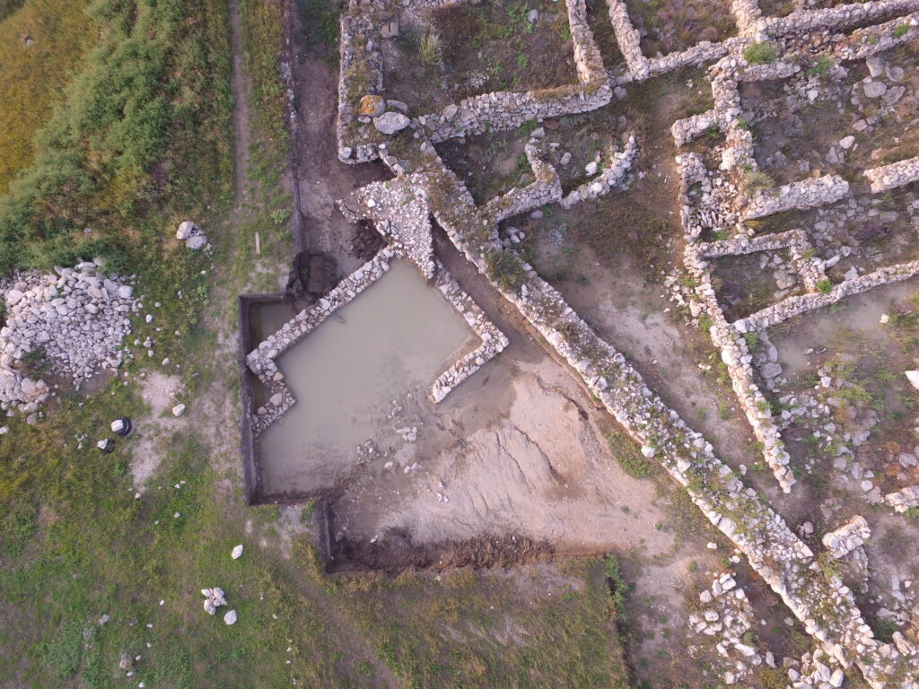
The “Polyanka” settlement is located in the Leninskii District of the Crimean Republic, five kilometres west of Zyuk Cape and on the shore of the Sea of Azov. It is situated in a small coastal valley and occupies an area of 0.85 hectares. To the West, North and East it is edged by limestone ridges and to the South there is a fairly large, uneven area sloping upwards and containing a number of rocky outcrops. To the North of the settlement an expanse of rock ends in a cliff dropping down to the shore. The land of the fortified settlement itself is also uneven: it consists of low natural terraces and the whole area slopes down towards the North-West (orthophoto).
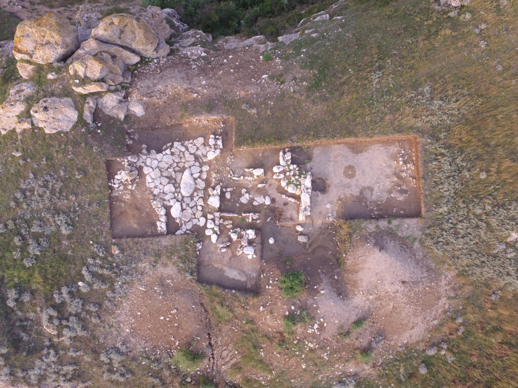
The site was discovered in 1982. Archaeological excavations were carried out there between 1984 and 1987 by the East-Crimean Expedition of the Institute of Archaeology (affiliated to the Russian Academy of Sciences), under A.A.Maslennikov (during that first period, the team was led by V.K.Golenko). In 2007 excavations were resumed and they have continued till the present day. The total excavation site, which now incorporates certain areas outside but close to the “Polyanka” settlement, extends over approximately 5,000 square metres. The specific interest of this archaeological site, apart from the features already mentioned (it is almost hidden in a hollow and does not dominate the surrounding area) lies in its stratigraphy and chronology. It would seem that east of the existing fortified settlement there had been a second, quite large one, on a rocky plateau in the 3rd and 2nd centuries BC, which by now has almost completely vanished. It would appear to have been swept away by some natural disaster. Virtually no remains of buildings have survived. Not only is there a layer (up to four metres thick and extensive) of ash and rubbish containing finds – such as might have been expected in a context of this kind and covering a large part of the hollow’s eastern slope – but it also stretches under virtually the whole of another, later settlement, which came into being at the end of the first quarter of the 1st century BC. At that time, or perhaps even earlier, a small ‘rural’ shrine had been in use on a plateau lying south-east of the site.
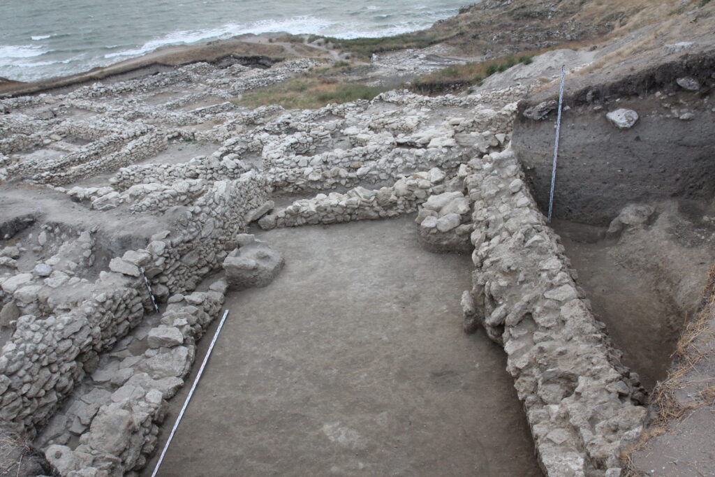
The lay-out of the “Polyanka” settlement takes into account the distinctive features of the terrain’s relief and consists of a series of linear terraces (four of them run East to West and one – the highest of them all – follows a North-South line). The terraces are divided from each other by two or three main streets and several minor ones, forming ‘districts’ consisting of one or more houses or basic structures. The total number of ‘districts’ is no less than 12-15. The overall nature of the lay-out used (the arrangement of the streets and districts mainly extending West-East) and also the presence of water pipes, small paved courtyards and even a square make it possible to speak of elements of regular planning and provision of amenities. In the lower (northern) part of the settlement the buildings were much closer together than elsewhere and their overall arrangement was rather chaotic. The single-storey dwellings and outbuildings there had been made of undressed local stones not laid out in any regular pattern: the structures were low ones and had most probably had the very simplest of rooves.

Yet some of these buildings had been quite large. One of them turned out to have been a community winery. Another large building, somewhat isolated in the northern part of “Polyanka”, had been a shrine inside the settlement. It yielded up numerous and diverse finds, most of which were of a sacral nature (around 50 intact and fragmentary terracotta figurines depicting Attis, Mena, Herakles, Aphrodite, Dionysos, Seilenos, Mithras and other syncretic deities, two tall incense burners bearing traces of paint, gilding et al.). In the adjacent room, two hoards were found consisting of 1,200 bronze coins from the Bosporan Kingdom, Pontic towns and Paphlagonia and dating from the 1st century BC. In general the finds from this fortified settlement, apart from those originating in the ash layer, were mostly of a similar kind and of only low value.
The latest structure – one of considerable size – is the defensive wall, several sections of which can be traced in its north-west, west, south and east parts. The latter section extends above the built-up area, leaving a significant proportion of the settlement outside it.
Attention should also be drawn to the fact that, thanks to the relatively good preservation of the structural remains of this wall, there are clear pointers in a number of places to distortion of the walls and also to signs of powerful seismic activity which must have occurred in antiquity. So far this particular site is one of the most thoroughly studied within a rural area of the Bosporus and has become a point of reference for the 1st century BC.
Analysis of the mass-scale finds and stratigraphic observations make it possible to specify when the population abandoned this site – namely the period between 12 and 9 BC.
The necropolis of the settlement has not been found.
The pottery stamps found at the “Polyanka” settlement (prior to 2017) have already been published by N.F.Fedoseev. He has also compiled a diagram to show the centres of production from which the stamps in this collection originated. A small number of imprints dates from the last third of the 4th century but most date from a period between the seventies of the 3rd century BC and the end of the 2nd century BC. Since 2017, 39 new stamps have been added to the collection (found in 2012 and 2018-2021) and certain previous errors and inaccuracies have been corrected.
Prof. Dr. A. A. Maslennikov